Saturday, December 4, 2010

Marin Headlands

Drool.

Living in the Presidio certainly has its perks.
Staring across the bay at the Marin Headlands tops that list for me.

If you've never been, the colorful cherts (Radiolarian is my new favorite!), pillow lava, and fault shear zones are worth the visit.
(Some great documentation of these is available here.

I'm still transitioning into my surrounds and a better understanding of the local geology since moving from Los Angeles and charts like the one below really fascinate me.

http://blackquartz.com/images/marinheadlands/SF_Terrane_map.gif

Chevron folding in fabulous radiolarian chert!


All this and a great view of Angel Island-- i.e. my next hiking/camping destination I need to visit!

Obligatory Music Break

Best Albums of 2010

1. Sea of Cowards - The Dead Weather
Brothers - The Black Keys
The XX - The XX
. Volume Two - She & Him
All Day - Girl Talk
The Suburbs - Arcade Fire
Transcontinental Hustle - Gogol Bordello
Transit Transit - Autolux
. Plastic Beach - Gorillaz
Conditions - The Temper Trap

(runners up! Spoon, The Heavy, Vampire Weekend, Edward Sharpe & the Magnetic Zeros, The National, Deerhunter, Waaves, ... and Them Crooked Vultures-- if Dec. 2009 counted )

Wednesday, October 20, 2010

Hiatus OVER!

Innocent blog, how I have neglected you.

Not only have my senior project, senior year, and college education ended completely, but I've moved to an even more geologically stimulating city: San Francisco!

I am hostessing (for now).
I am writing (often!) in my huge new backyard (Presidio National Park!) and endlessly searching new places to explore.

I feel as I have returned to Paris where everyone doesn't smoke, speak French, and make tiny mouth-breathing noises so much ...as the French tend to do. The Bay Area folk just tend to say hella a lot less than expected, love food more than children, and have tumultuous love affairs with the Giants during the MLB playoffs.

Back to GEOLOGY.
Tomorrow I'm off to one of my unmentioned dream destinations: Pyramid Lake, Nevada.
Not only do we get to stop in the fun gold-miner town Truckee, but I get to figure out what Tufa looks like up close.

Tufa: rocks that grow due to evaporation of lime-rich waters, forming a calcite crystal residue.

Even the USGS diagrams are beautiful. I would totally frame and hang this on my unfurnished new studio's walls:


Excited to vacate the city for a few rainy fall days and search for life in an ancient lake, with ancient fish to boot.

Thursday, January 21, 2010

Landmudlifedebris Flow


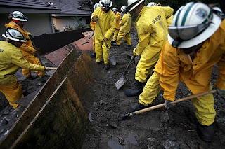
Amidst the snow-covered power-outages and desert road tornadoes along the 10 interstate, Los Angeles communities are suffering from post-wildfire damages and are [smartly] being evacuated all over again.

"In the upper reaches of suburban La Canada Flintridge, where mountainsides rise sharply from the backyards of homes, authorities put pink ribbons on the mailboxes of residents who stayed behind so they would know where to search in the event of a catastrophe.

One person who stayed was Delos Tucker, a retired geologist who has lived in the community since the homes were built in 1962.

'I'm just gambling it's not going to happen,' he said. ''Let's hope I'm right.''"

(LA Times article/photos)

As the FIFTH storm blows in, and my cabin fever here in Whittier (especially without a physical class to attend) is driving me slowly out of my mind. My three trips outside were to collect mail, food, and rescue a discarded, waterlogged Kendall organ along the street-- during which I found phenomenal floods and undiscovered crevices left along adjacent properties from the Narrows quake.

Next week begins the route toward The End. The Senior Project draft is drafted. The research is cited. The community is under siege for my interviews and answers for future disaster preparations. My petition to save my inspirational advisor's career at Whittier will be further circulated (50 signatures already!). I hope to end this chapter in Whittier, California with a bit more resolve and optimism before I head up north to chase the big green clouds up in San Francisco.

Friday, December 11, 2009

Let's go Hopenhagen- PLEASE HELP!

Some of the most endangered communities that will be inevitably threatened by the rising waters caused by the climate crisis are small island communities in the South Pacific-- like Tuvalu, for example. As a member of the Powershift Rapid Response team, which works to "connect the action at the climate negotiations in Copenhagen," I am greatly concerned about maintaining solidarity with the international progress that could take place to benefit every island, peninsula, or landmass.

Please, take a minute to make a phone call to the President's Comment Line:
Can you call President Obama right now at 202-456-1111.

Keep your message concise, and for your pleasure, here is the script I read from, but feel free to express how you stand with Tuvalu and call for a legally binding 350ppm limit in your own wonderful words.

"Hello, my name is ______. I'm live in ________/ I'm a student at __________. President Obama, over 500 youth in Copenhagen and thousands of youth back home are calling on you to ensure the future of small island nations like Tuvalu and the future of all generations. The US must play a lead role in securing a legally binding, scientific based deal that limits carbon pollution to 350ppm."

Tuvalu, a small island nation in the Pacific Ocean, called for an open conversation about a legally binding deal. Despite the request only being for the start of a conversation, several larger countries blocked the idea. Tuvalu is calling for a legally binding deal and has repeatedly called for a return to 350ppm carbon. We need to stand with Tuvalu. The Rapid Response Team is working to call President Obama right now. Can you call the White House to show your support for Tuvalu and a legally binding limit of 350ppm CO2 for a safe climate future. President Obama needs to lead, and we need to ask him to do this.

Thanks,
Ty

Wednesday, December 9, 2009

The Light in Sight...

Nearing the end of my last Fall semester at Whittier, counting the days until the best holiday gift of all: a road trip with mom from Northern California to Flagstaff.

Narrowing down ideas for pit stops... I think we're either going to check out the lava beds, joshua trees, and petroglyphs at Mojave National Preserve if Yosemite is too chilly/snowy/closed. (Mitchell Caverns below)VallesCaldera.com has a great collection of must-see parks, and their Mojave photo (below) has me sold on the idea of trekking down some lava tubes, checking out some cheesy tefoni, and walking amongst the hoodoos.

They say:

"Singing sand dunes, volcanic cinder cones, Joshua Tree forests, and carpets of wildflowers are all found at this 1,534,819-acre preserve that protects a massive swath of the Mojave Desert of Southern California. A visit to its canyons, mountains and mesas will reveal long-abandoned mines, homesteads, rock-walled military outposts, and a historic railroad depot.

The preserve was created by an act of Congress — the California Desert Protection Act of 1994 — which also elevated Southern California’s Joshua Tree and Death Valley National Monuments to national park status. Prior to this act, the area was administered as the East Mojave National Scenic Area, under the jurisdiction of the Bureau of Land Management.

537,250 people visited the Preserve in 2006."

<-- Petroglyph Point by ex-magician on flickr


Meanwhile, I'm constructing my list of future visits since my finals are winding down and my senior project seems close to possible to complete by April...


Tyler's National Park/Geological Sites Bucket List (in no particular order)

  • Grand Tetons & Yellowstone, WY
  • Canyon de Chelley, AZ
  • Shiprock, NM
  • Carlsbad Caverns, NM
  • Hopi Buttes, AZ
  • Chaco Culture National Historic Park, NM
  • Valles Caldera, NM
  • Bryce Canyon, UT
  • Priest Lake, ID
  • Yosemite, CA
  • Desert Valley, CA
  • Channel Islands, CA
  • Monument Valley, AZ
  • Muir Woods, CA
  • Redwood National/State Parks, CA
  • Juan Bautista de Anza National Historic Trail, CA
  • Volcanoes National Park, HI
  • Bering Land Bridge National Preserve, AK
  • Craters of the Moon National Landmark & Preserve, ID
  • Glacier Bay National Park, AK
  • Jean Lafitte Historical Park & Preserve, LA
  • Grand Canyon North Rim & Vulcan's Throne, AZ
  • Point Reyes National Seashore, CA
  • Sequoia & Kings Canyon, CA
  • Joshua Tree, CA
  • Lassen Vocanic National Park, CA
  • Devils Postpile, CA
  • Wrangell-St. Elias National Park and Preserve, AK
  • Cathedral Valley, UT
  • Zion National Park, UT
  • Devil's Playground, UT
  • Fremont Indian State Park/Castle Rock, UT
  • Kaniakapupu, HI
  • Badlands National Park, SD
  • Fort Rock, OR
  • Mt. Vesuvius National Park, Italy

Already Visited
  • Sunset National Crater, AZ
  • Petrified National Forest, AZ
  • Grand Canyon (South Rim), AZ
  • Cabrillo National Monument, CA
  • Big Rock Candy Mountain, UT
  • Red Rock Canyon, NV
  • Tonto Natural Bridge, AZ
  • Wutpatki, AZ
  • Painted Desert, AZ
  • Carson National Park, NM (the search for epic fairy crosses)
  • White River National Forest, CO
  • Petroglyph National Monument, CA
  • Pu'u o Mahuka Heiau State Historic & Religious Site, HI
  • James Campell National Wildlife Refuge, Haleiwa, HI
To be continued...

Tuesday, November 17, 2009

Malibu Creek State Park: My personal photography for a change...


Gotta love escaping the city, even if it means enduring traffic on a Saturday in Los Angeles... I found myself and four friends scrambling around the rocks of the jagged Goat Buttes right around dusk and through the empty creek beds of Malibu Creek State Park-- which were coated with, and maybe someone can correct me if I'm wrong, what seemed like white or decaying algae. Pretty crazy.

The 7,000 acres of public land are best understood in regards to geology with a quote from geocaching.com (I just signed up-- free!):

"The Conejo Volcanics are an entire series of igneous rocks that came from a volcano (possibly 3) located in the western Santa Monica Mountains. One of the eruptions blew apart the overlying rock into large angular chunks (the breccia) as it spewed lava, in this case basalt and ash. As this mix of material came down and/or flowed across the landscape it cooled with the pieces of other rock inside it combining to become the basaltic breccia. You can also see the gas that was still trapped in the basalt as it cooled and formed small bubbles in the rock."

I guess Sugarloaf Peak may have been the inspiration for Paramount Pictures' logo... huh. Plenty of cinematic value within this park.

I need to bring to attention the role wikipedia (along with flickr and google reader) plays in my geological learning experience due to Whittier College's geology department being under construction... I donated and recommend everyone who can give a little should: Wikipedia Affiliate Button

Next trip is either Topanga Canyon, Gillette Ranch, secret waterfall in Pasadena... and I still gotta get up to Griffith Park before I graduate. Boy it's tough living in Whittier without a car sometimes, when so many geological explorations are only within a few hours of driving.

P.S. If anyone reads this and knows of any interesting geological work in the SF Bay area, please please feel free to email me.

Followers

About Me

My photo
I am an eco-nazi flaneur stuck in East LA.